|
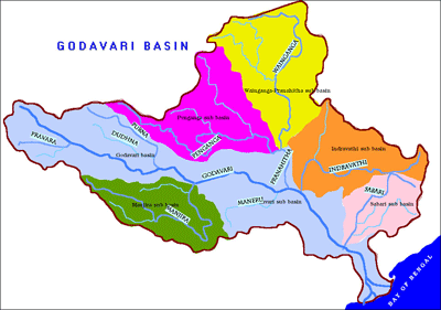
Tributaries of Godavari
The peculiar characteristic of the river Godavari is that it receives most of its water not from the Western Ghats but in the lower reaches. The Manjira, the Pranahita, the Indravati and Sabari contribute 6%, 40%, 20% and 10% of the waters respectively.
The principal tributaries of the river are
-
Pravara,
-
Purna,
-
Manjira,
-
Penganga,
-
Wardha,
-
Wainganga,
-
Pranahitha
-
Kinnerasani
-
Sabari
-
Indravati and
-
Kolab.
-
Machkund
Pravara 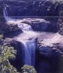
Pravara is tributary of the river Godavari. Waters of the river Pravara fall from a great height, creating the Randha Falls. The Pravara rises on the eastern slopes of the Sahayadris between Kulang and Ratangad. After the sinuous course of twelve miles in an easterly direction, near the village Ranad, it falls into rocky chasm 200 feet deep,and then winds for eight miles through a deep narrow glen which opens wider valley east of and below the central plateau on which the town of Rajur stands. Total Length of Pravara is 120 miles. The Dam Bhandardara is constructed across the river at Bhandardara, near by are the Randha falls.
Purna
 The river Purna which is tributary of Godavari, rises in Betul district of Madhya Pradesh and flows due west across Akola district into Buldana district of Maharashtra. It passes from east to west through the northern part of the Parbhani district and joins the Godavari at Kantheshwar in Purna Taluka. The river Purna which is tributary of Godavari, rises in Betul district of Madhya Pradesh and flows due west across Akola district into Buldana district of Maharashtra. It passes from east to west through the northern part of the Parbhani district and joins the Godavari at Kantheshwar in Purna Taluka.
The chief tributaries of the Purna on the south bank are the Pendhi, Uma, Katepurna, Nirguna and Man. The Katepurna, the largest of all tributaries, rises within a few kilometres of Washim and flows across the eastern side of Akola tehsil and the northwestern corner of Murtizapur. Major Dams on the Purna River are Yeldari Dam (Hydroelectric Power Station) in Jintur Tehsil of Parbhani district.
Manjira
Major tributary of Godavari, arising in Balaghat hills. It contributes to around 6% of the total waters of Godavari. Manjira River flows along the eastern boundary of the Nanded district towards the north. Later it meets the Godavari. Manyad and Lendi are the tributaries of the river. Manjeera is a tributary of river Godavari and is a principal river flowing in Nizamabad district. It raises in the Balaghat hills and enters Andhra Pradesh in Medak district.
Penganga
Penganga River is one of the tributaries of Godavari River. Kayadhu is the tributary of this river. It flows along the northern boundary of the Nanded district and a huge amount of land is irrigated by a project named " Upper Penganga Prakalp" built on this river. The famous Sahastrakund falls on this river.
Wardha:
Wardha is the tributary of River Godavari. It originates from the Mutai plateau of the Satpuda range and flows along the entire northern and western border of the Wardha district.
The main tributaries are Bor, Dham, Pothra, Asoda and Wunna. Upper Wardha Dam is situated at Simbhora, 8-km towards the East from Morshi and 56-km from Amravati. It is build up on the Wardha River. It is an earthen dam with a height of 36m and 7-km length and on the boundary of Amravati and Wardha Districts. Its irrigation capacity is nearly 75,000 hectares of land in these two districts. A tourism centre is being developed at this site. It is now named as Nal - Damyanti Sagar.
Wainganga:
 Wainganga is the tributary of River Godavari. Wainganga River receives numerous tributaries on either bank and drains the western, central and eastern regions of the Chandrapur and Nagpur district. The chief tributaries of the Wainganga are Garhavi, Khobragadi, Kathani and Potphondi on the left bank and Andhari on the Right Bank. Wainganga is the tributary of River Godavari. Wainganga River receives numerous tributaries on either bank and drains the western, central and eastern regions of the Chandrapur and Nagpur district. The chief tributaries of the Wainganga are Garhavi, Khobragadi, Kathani and Potphondi on the left bank and Andhari on the Right Bank.
Pranahita
The Pranahita is an important tributary of the Godavari and is formed by the confluence of the Penganga, the Wardha and the Waiganga. Rising in the Satpura hills, it enters Andhra Pradesh in Adilabad district and mingles into river Godavari at Chennur.
Kinnerasani
Matter to be filled
Sabari
 The river Sabari is a tributary to the River Godavari. It merges with the river Godavari in Kunavaram, about 40-km from Bhadrachalam. Sileru is a tributary of river Sabari and it flows through the Srikakulam district of Andhra Pradesh. The river Sabari is a tributary to the River Godavari. It merges with the river Godavari in Kunavaram, about 40-km from Bhadrachalam. Sileru is a tributary of river Sabari and it flows through the Srikakulam district of Andhra Pradesh.
Indravati
 Indravati is an important tributary of river Godavari and contributes to about 20% of the waters of Godavari. It is the largest and the most important river in Bastar district of Orissa. Indravati is an important tributary of river Godavari and contributes to about 20% of the waters of Godavari. It is the largest and the most important river in Bastar district of Orissa.
The Indravati river rises from Rampur Thuamul in the Orissa state and flowing through the Bastar division for about 240 miles, it finally merges into the Godavari at Bhadrakali in Dantewada district. Owing to its rocky bed the river is not navigable except near its junction at Godavari. Neither the river nor its tributaries dry up in the hot season.
 The Indravathi starts from the jungles of Kalahandi and after receiving a number of perennial hill streams, rising in Kashipur tahsil and Norangpur and Koraput subdivisions, it enters Bastar after flowing through Nowrangpur and Kotpad tahsils. The Bhaskel joins it just before it leaves Koraput district. It forms the beautiful Chitrakota falls about 25 miles west of Jagdalpur in Bastar district. The total length is 329 miles, of which 77 miles run through Koraput district or along its boundary. The Indravathi starts from the jungles of Kalahandi and after receiving a number of perennial hill streams, rising in Kashipur tahsil and Norangpur and Koraput subdivisions, it enters Bastar after flowing through Nowrangpur and Kotpad tahsils. The Bhaskel joins it just before it leaves Koraput district. It forms the beautiful Chitrakota falls about 25 miles west of Jagdalpur in Bastar district. The total length is 329 miles, of which 77 miles run through Koraput district or along its boundary.
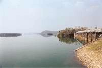
Kolab
The Kolab rises near Sinkaram hill on the 3000 foot plateau, flows north-west in a winding bend, passing five miles to the south of Koraput and falls down to the 2000 foot plateau not far south of Jeypore. At the end of its descent to the Jeypore plateau the river is spanned by a fine bridge near Kotta. It flows right across the Jeypore tahsil in a north-westerly direction for 20 to 30 miles and then suddenly doubles back and runs nearly 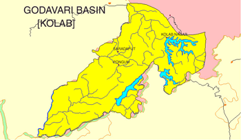 south, forming the boundary between Koraput and Bastar. It then runs south back into this district forming, for a few miles, the boundary between the Nowrangpur and Malkanagiri subdivisions passing at this point through a gorge in the will hills west of Ramagiri, which are called Tulisi Dongar range. As it issues from this it falls about 49 feet into a large pool, 12 or 14 feet deep, into which in days gone by, as tradition goes, witches used to be thrown with a stone round their neck. Turning west again, and passing Salimi, the river flows into Bastar, past Sukuma, and at last again divides Bastar from Koraput, forming the western boundary of Malkanagiri subdivision for many miles. In this last part of its course, it is called the Sabari. At Motu the extreme south-western corner of the subdivision it meets the Sileru, and the two pass out of Orissa into Andhra Pradesh and fall eventually into the Godavari river. The total length of the Kolab and Sabari is 280 miles, of which all but 55 miles flow through Koraput district or along its boundary. south, forming the boundary between Koraput and Bastar. It then runs south back into this district forming, for a few miles, the boundary between the Nowrangpur and Malkanagiri subdivisions passing at this point through a gorge in the will hills west of Ramagiri, which are called Tulisi Dongar range. As it issues from this it falls about 49 feet into a large pool, 12 or 14 feet deep, into which in days gone by, as tradition goes, witches used to be thrown with a stone round their neck. Turning west again, and passing Salimi, the river flows into Bastar, past Sukuma, and at last again divides Bastar from Koraput, forming the western boundary of Malkanagiri subdivision for many miles. In this last part of its course, it is called the Sabari. At Motu the extreme south-western corner of the subdivision it meets the Sileru, and the two pass out of Orissa into Andhra Pradesh and fall eventually into the Godavari river. The total length of the Kolab and Sabari is 280 miles, of which all but 55 miles flow through Koraput district or along its boundary.
STUDY WHERE TO PUT (sub tributary of what?)
Machkund
The Machkund rises in the Madgol hills of Visakhapatnam district on the 3000 foot plateau, and near Wondragedda, not many miles off its sources, it becomes the boundary between Andhra Pradesh and Orissa. for some 30 miles or more the river runs nearly north along a very meandering course through the wide Padwa valley. When about 39 miles south of Jeypore it winds westward along the edge of the plateau as if looking for a way down through the low hills which fringe the plateau there, and then suddenly turns at a sharp angle to the south-west down a steep descent. The drop changes a somewhat sluggish river flowing between banks of red earth into a series of rapids foaming between enormous masses o boulders. Three miles from the bend and about the same distance south of Badigada the descent is barred by a huge barrier or rock shut in on either side by walls of rock two or three hundred feet in height. Below this is a sheer abyss over which the river used to fling itself into a boiling pool half hidden by dense clouds of spray, on which the sunlight used to throw the brightest of rainbows. In the dry season it was possible to scramble to the edge of the abyss and look straight down through the spray into the great pool beneath, while from beneath the scene was the most impressive, inspiring a mixed sense of awe and beauty in the minds of the visitors. But, with the diversion of the stream and installation of the Mackhund Hydro-electric project that beautiful sight is no more to be seen. These falls, with a 540 foot drop, are known by the name Duduma falls presumably in the absence of an adjacent village to name them after, as the word ‘Duduma' itself means ‘Waterfall'. Below the falls for three or four miles the river flows towards the south-west in a deep and a gloomy gorge, hemmed in on both sides by rock walls seven or eight hundred feet high into which it is impossible to descend except by the winch or the flight of steps of the Machkund project. The river flows down this narrow valley shut in by high hills till it reaches Kondakamberu 42 miles from Badigada. This valley of the Machkund is the most inaccessible and the least populated region in the whole district. At rare intervals on the way one meets a small village of primitive tribes named Didayis, who are not found anywhere but in this valley , while at one point the path runs through dense forests for fifteen miles without any sight of human habitation. The surrounding forest serves as admirable abode of wildlife and even in the middle of summer there is a broad stream in the river some two feet deep. It would be possible to make the whole journey from the falls to Kondakamberu in a dug out canoe at any time of the year. At Kondakamberu (1400 feet above sea level) the river is some 8 yards wide and unfordable at all seasons. It is now joined by a large tributary, the Gurrapurevu which rises in the high hills of Madgol and flows entirely through forest down a steep and rocky course. A few miles beyond Kondakamberu the river assumes the name ‘Sileru' (Rocky stream) and once again becomes the boundary of the Orissa state, separating it this time form the East Godavari district of Andhra Pradesh. It flows on by a much steeper gradient than before, abounding in mahseer and crocodiles, until at Motu it joins Sabari. Nothing can excel the supreme beauty of this lonely river, with its bamboo-covered banks, its deep long reaches of water, its falls, its grass-covered islets and its rushing clear water. Its length is 184 miles, of which there is a 38 mile through the Koraput district, and 120 miles along its boundaries.
An average annual surface water potential of 110.5 km3 has been assessed in this basin. Out of this, 76.3 km3 is utilisable water. Culturable area in the basin is about 18.9 Million ha, which is 9.7% of the total culturable area of the country.
Present use of surface water in the basin is 41.0 km3. Live storage capacity in the basin has increased significantly since independence. The hydropower potential of the basin has been assessed as 5091 MW at 60% load factor.
Chek it
PARTICULARS OF THE PRINCIPAL TRIBUTARIES OF GODAVARI
| |
|
River |
Source |
Sub-tributaries |
Length (km.) |
Catchment area (sq.km.) |
|
1 |
2 |
3 |
4 |
5 |
|
Pravara |
Western ghats |
Mula |
200 |
6,537 |
|
Purna |
Ajantha Hills |
|
373 |
15,579 |
|
Manjira |
Balaghat |
Tima, Kanaya |
724 |
30,844 |
|
Penganga |
Buldana range |
Pus, Arns, Aran |
676 |
23,895 |
|
|
|