|
GODAVARI BASIN DETAILS
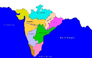
Godavari Basin extends over an area of 312,812 km2, which is nearly 9.5% of the total geographical area of the country. The basin lies in the states of
Maharashtra 1,52,199 km2 48.65 %
Andhra Pradesh 73,201 km2 23.40 %
Chattisgarh 39,087 km2 12.49 %
Madhya Pradesh 26,168 km2 8.63 %
Orissa 17,752 km2 and 5.67 %
Karnataka 4,405 km2 1.41 %
The Godavari, Perennial River of India is the Second largest river in India. It flows in the southern India and is considered to be one of the seven sacred rivers. The Godavari, throughout its entire length, is sacred to the Hindus.
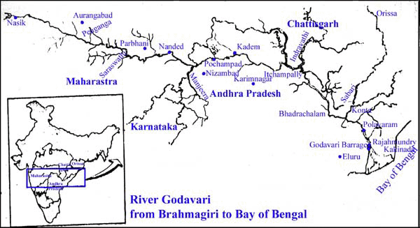
Godavari River rises near Trayambak near Nasik, northeast of Mumbai in the state of Maharashtra at an elevation of 1067 m and flows for a length of about 1465 km (910 miles) before out falling into the Bay of Bengal. It flows for 692-Kms before entering Andhra Pradesh at Basara in Adilabad district. It flows through the Eastern Ghats and emerges out at Polavaram into the plains. At Dhawaleswaram the river divides into two branches, the Gautami and Vasishta. Between the two lies the Godavari Central Delta. The two arms split into branches as they approach the sea dividing the Central Delta into a number of islands. These branches are said to have been made by seven great 'Rishis' after whom they are named. Godavari is known as the "Ganga of the South". Asia's largest Lift irrigation project named "Vishnupuri Prakalp" is constructed on the river just 5-km away from Nanded city.
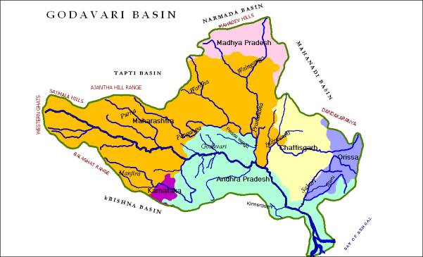
The Godavari basin is bounded on the North by the Satmala Hills, the Ajanta Range and the Mahadeo Hills, on the South and East by the Eastern Ghats and on the West by the Western Ghats. It is roughly triangular in shape and the main river itself runs practically along the base of the triangle.
Basin characteristics
The Godavari basin receives major part of its rainfall during the Southwest monsoon period. The other rainy seasons are not so well defined and well spread as the South-West monsoon season. They contribute about 16% of the total annual rainfall in the Godavari basin. The annual rainfall of Godavari basin varies from 3000 mm to 600 mm. The Godavari basin has a tropical climate. The mean annual surface temperature in the Western Ghat area is about 24oC, and it increases gradually towards the east and attains a maximum of 29.4oC on the East Coast. During January the mean daily minimum temperature increases from West to East from 15oC on the Western Ghats to about 18oC on the East Coast. The mean maximum daily temperature generally exceeds 30oC in the western part of the Godavari basin and it is only slightly less than 30oC in the Eastern part.
The population of the basin, based on 2001 census was 60.57 million out of which about 75% live in rural and remaining 25% in urban areas. The density of population is around 194 persons per km2. Nearly 40% of work force is engaged in cultivation, 30% as agriculture labour and balance 30% in mining, manufacturing etc.
Except for the hills forming the watershed around the basin, the entire drainage basin of the river Godavari comprises of undulating country, a series of ridges and valleys interspersed with low hill ranges. Large flat areas which are characteristic of the Indo-Gangetic plains are scarce except in the delta. The Sahyadri ranges of Western Ghats form the Western edge of the basin. The interior of the basin is a plateau divided into a series of valleys sloping generally towards East. The Eastern Ghats, which form the Eastern boundary, are not so well defined as the Sahyadri range on the West. The Northern boundary of the basin comprises of tablelands with varying elevation. Large stretches of plains interspersed by hill ranges lie to the South.
|